In spring 2014 the Natural History Museum Vienna and the University of Bern joined forces to carry out analyses on sediment
layers at the bottom of Hallstaetter See lake. They were supported by the voluntary fire brigade and municipal council in
Hallstatt as well as by the Austrian Federal Forestry Office. The results of the analyses tell us much about environmental
incidents and changes in the climate that have left behind traces in the mud. Such incidents include rockfalls, landslides,
flooding and earthquakes. Moreover, further research can tell us when these environmental incidents occurred.
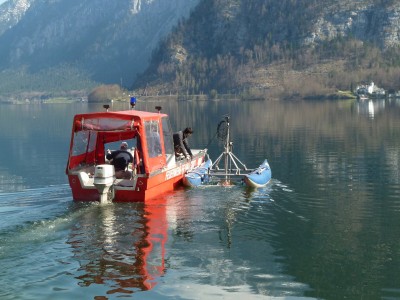
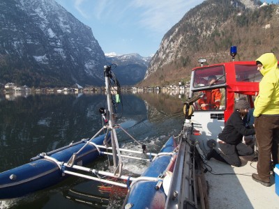
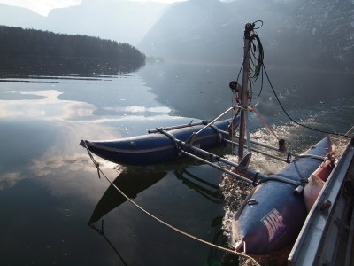
Seismic reflection was used to gather the data. Sound waves were sent from a boat on the lake’s surface down to the bed, where they were reflected by the different layers of sediment and bounced back up to the recording device. These reflected waves provided information not only on how thick and how large each of the layers is, but also about their structure and ideal locations for taking samples. In order to analyze the whole lakebed, the area was first divided into sections. A sediment probe measuring 1m in depth was then taken from each section where researchers had identified layers with information on past incidents. The results are currently being analyzed as part of a master thesis written by Enrica Rohrbach at the University of Bern. Her thesis supervisor, Dr Flavio Anselmetti, has already confirmed that the data collected contain a wealth of information about the long history of the Hallstaettersee lake.
The first step is to analyze the samples in detail to determine characteristics such as sediment type, grain size, density, fossil content, chemical composition and the order of the different layers. Regardless of how these analyses turn out, the results of the seismic reflection (known as “seismic profiles”) are investigated in order to identify special units, landslides, earth movements and other events of interest. If such incidents are found they are combined with each other and illustrated using 3D modelling. Then it is time to merge the results of the sediment analyses with the results of the seismic analyses, thereby generating a comprehensive image of the top layer of the lakebed reflecting environmental incidents, the thickness of the different layers and the different types of sediment in them.
So far researchers have managed to generate an initial overview of the seismic profiles. The high levels of methane contained in the bed of the Halstättersee lake as a result of the decaying organic material meant that the sonic waves were only able to penetrate to a depth of a few meters. Researchers have also opened and photographed the drill cores containing the sediment samples.
(Kowarik, K. - Loew, C.)